Non-Hazardous Landfill: Difference between revisions
Added reference |
|||
| (44 intermediate revisions by 5 users not shown) | |||
| Line 1: | Line 1: | ||
[[Category:Technologies & Solutions]] | [[Category:Technologies & Solutions]] | ||
Only a Non- | Only a [[Non-Hazardous Landfill]] can accept [[Non-Hazardous Waste]] which includes [[Municipal Solid Waste]] (MSW) and any other [[Non-Hazardous Waste]] of a similar nature that meets the relevant [[Waste Acceptance Criteria]] ([[WAC]]). | ||
==Arrangements== | |||
Only a [[Non-Hazardous Landfill]] can accept [[Non-Hazardous Waste]] which includes [[Municipal Solid Waste]] (MSW) and any other [[Non-Hazardous Waste]] of a similar nature that meets the relevant [[Waste Acceptance Criteria]]. They can also accept [[Inert Waste]] and [[Stabilised Non-Reactive Hazardous Waste]] (SNRHW), for example those vitrified or solidified<ref>Defra, 2010. [https://assets.publishing.service.gov.uk/government/uploads/system/uploads/attachment_data/file/69347/pb13563-landfill-directive-100322.pdf Environmental Permitting Guidance: The Landfill Directive for the Environmental Permitting (England and Wales) Regulations 2010. London: Department for Environment, Food and Rural Affairs], p.7.</ref>. The WikiWaste page '''[[Landfill]]''' frames these types of sites and puts them into a wider context. | |||
==Non-Hazardous Landfill Capacity (Void)== | |||
===England=== | |||
The capacity of Non-Hazardous Landfill is reported<ref>[https://data.gov.uk/dataset/237825cb-dc10-4c53-8446-1bcd35614c12/remaining-landfill-capacity EA Remaining Landfill Capacity]</ref> by the [[EA]] for England and is summarised in the graph and table below, but it excludes that capacity of Non-Hazardous Landfill with a Stabilised Non-Reactive Hazardous Waste cell (which comprised 89.4 million cubic metres in 2015 dropping to 69.4 million cubic metres in 2019 and 67 million cubic metres in 2020 - which is summarised on the [[Hazardous Landfill]] page). Note that Non-Hazardous Landfill also provides [[Landfill]] capacity for [[Inert Waste]] in the sense that these waste are used for daily cover and site engineering purposes. | |||
The number of sites in 2020 in England was 113, a drop from 118 in 2019, whilst capacity increased between the two years. | |||
{|style="margin: auto;" | |||
|+style="caption-side:bottom;"|Changes in Non-Hazardous Landfill Capacity | |||
|- | |||
| <graph>{ | |||
"width":400, | |||
"height":200, | |||
"data":[{ | |||
"name":"table", | |||
"values":[ | |||
{"x":2015,"y":230.3},{"x":2016,"y":211.9},{"x":2017,"y":194.4}, | |||
{"x":2018,"y":185.2},{"x":2019,"y":160.2},{"x":2020,"y":164.8} | |||
] | |||
}], | |||
"scales": [ | |||
{ | |||
"name": "x", | |||
"type": "linear", | |||
"range": "width", | |||
"zero": false, | |||
"domain": {"data": "table", "field": "x"} | |||
}, | |||
{ | |||
"name": "y", | |||
"type": "linear", | |||
"range": "height", | |||
"nice": true, | |||
"domain": {"data": "table", "field": "y"} | |||
} | |||
], | |||
"axes": [ | |||
{"type": "x", "scale": "x", "format":"d","title":"Year"}, | |||
{"type": "y", "scale": "y", "grid":true, "title":"Million Cubic Metres"} | |||
], | |||
"marks": [ | |||
{ | |||
"type": "line", | |||
"from": {"data": "table"}, | |||
"properties": { | |||
"enter": { | |||
"x": {"scale": "x", "field": "x"}, | |||
"y": {"scale": "y", "field": "y"}, | |||
"stroke": {"value": "steelblue"}, | |||
"strokeWidth":{"value":2} | |||
} | |||
} | |||
}, | |||
{ | |||
"type": "symbol", | |||
"from": {"data": "table"}, | |||
"properties": { | |||
"enter": { | |||
"x": {"scale":"x","field": "x"}, | |||
"y": {"scale":"y","field": "y"}, | |||
"fill": {"value": "steelblue"}, | |||
"size":{"value":15} | |||
} | |||
} | |||
} | |||
] | |||
}</graph> | |||
|- | |||
{|class="wikitable" style="margin: auto;" | |||
|- | |||
|+Table Summarizing Graph Data | |||
|'''Year''' || 2015 || 2016 || 2017 || 2018|| 2019 || 2020 | |||
|- | |||
|'''Million Cubic Metres''' || 230.3 || 211.9 || 194.4 || 185.2 || 160.2 || 164.8 | |||
|} | |||
|} | |||
===England by Region=== | |||
All data 2020<ref>[https://data.gov.uk/dataset/237825cb-dc10-4c53-8446-1bcd35614c12/remaining-landfill-capacity EA Remaining Landfill Capacity]</ref>. Please note that the "Number of Sites" in the table below relates to those sites that have returned a reported void. This figure does not necessarily correspond to the total number of sites in a region. | |||
{{#clear_external_data:}} | |||
{{#get_db_data: | |||
db=engy | |||
|from=lfvoidrgn | |||
|where=year=2020 and class='Non-Hazardous Landfill' and cntry = 'England' | |||
|data=rgn=rgn, num=num, void=void, avgvoid=avgvoid | |||
|order by=rgn | |||
|suppress error | |||
}} | |||
{| class="wikitable" | |||
! Region !! Number of Sites !! Total Void (m<sup>3</sup>) !! Average Void per site (m<sup>3</sup>){{#for_external_table:<nowiki/> | |||
{{!}}- | |||
{{!}} {{{rgn}}} | |||
{{!}} {{{num}}} | |||
{{!}} {{{void}}} | |||
{{!}} {{{avgvoid}}} | |||
}} | |||
|} | |||
===Scotland=== | |||
All Data for 2019, owning to a cyber attack at [[SEPA]] there is currently no 2020 data. | |||
{{#clear_external_data:}} | |||
{{#get_db_data: | |||
db=engy | |||
|from=lfvoidrgn | |||
|where=year=2019 and class='Non-Hazardous Landfill' and cntry = 'Scotland' | |||
|data=rgn=rgn, num=num, void=void, avgvoid=avgvoid | |||
|order by=rgn | |||
|suppress error | |||
}} | |||
{| class="wikitable" | |||
! Region !! Number of Sites !! Total Void (t) !! Average Void per site (t){{#for_external_table:<nowiki/> | |||
{{!}}- | |||
{{!}} {{{rgn}}} | |||
{{!}} {{{num}}} | |||
{{!}} {{{void}}} | |||
{{!}} {{{avgvoid}}} | |||
}} | |||
|} | |||
===Wales=== | |||
Void data for 2018 for wales, Site Count Data is 2020. | |||
{{#clear_external_data:}} | |||
{{#get_db_data: | |||
db=engy | |||
|from=lfvoidrgn | |||
|where=year=2018 and class='Non-Hazardous Landfill' and cntry = 'Wales' | |||
|data=rgn=rgn, num=num, void=void, avgvoid=avgvoid | |||
|order by=rgn | |||
|suppress error | |||
}} | |||
{| class="wikitable" | |||
! Region !! Number of Sites !! Total Void (m<sup>3</sup>) !! Average Void per site (m<sup>3</sup>){{#for_external_table:<nowiki/> | |||
{{!}}- | |||
{{!}} {{{rgn}}} | |||
{{!}} {{{num}}} | |||
{{!}} {{{void}}} | |||
{{!}} {{{avgvoid}}} | |||
}} | |||
|} | |||
==Operational Landfill== | |||
===East Midlands=== | |||
{{#clear_external_data:}} | |||
{{#get_db_data: db=engy |from=lfsites| where=classification='Non-Hazardous Landfill' and region='East Midlands' |data=site=site,id=id,operator=operator}} | |||
[[File:Lf map emids nonhaz.png|500px|right]] | |||
{|Class="wikitable sortable" | |||
! ID !! Site Name !! Operator | |||
{{#for_external_table:<nowiki/> | |||
{{!}}- | |||
{{!}} {{{id}}}. | |||
{{!}} [[{{{site}}}]] | |||
{{!}} [[{{{operator}}}]] | |||
}} | |||
|} | |||
<br clear='all' /> | |||
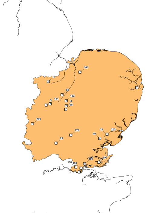
===East of England=== | |||
{{#clear_external_data:}} | |||
{{#get_db_data: db=engy |from=lfsites| where=classification='Non-Hazardous Landfill' and region='East of England' |data=site=site,id=id,operator=operator}} | |||
[[File:Lf map eengl nonhaz.png|500px|right]] | |||
{|Class="wikitable sortable" | |||
! ID !! Site Name !! Operator | |||
{{#for_external_table:<nowiki/> | |||
{{!}}- | |||
{{!}} {{{id}}}. | |||
{{!}} [[{{{site}}}]] | |||
{{!}} [[{{{operator}}}]] | |||
}} | |||
|} | |||
<br clear='all' /> | |||
===London=== | |||
{{#clear_external_data:}} | |||
{{#get_db_data: db=engy |from=lfsites| where=classification='Non-Hazardous Landfill' and region='London' |data=site=site,id=id,operator=operator}} | |||
[[File:Lf map london nonhaz.png|500px|right]] | |||
{|Class="wikitable sortable" | |||
! ID !! Site Name !! Operator | |||
{{#for_external_table:<nowiki/> | |||
{{!}}- | |||
{{!}} {{{id}}}. | |||
{{!}} [[{{{site}}}]] | |||
{{!}} [[{{{operator}}}]] | |||
}} | |||
|} | |||
<br clear='all' /> | |||
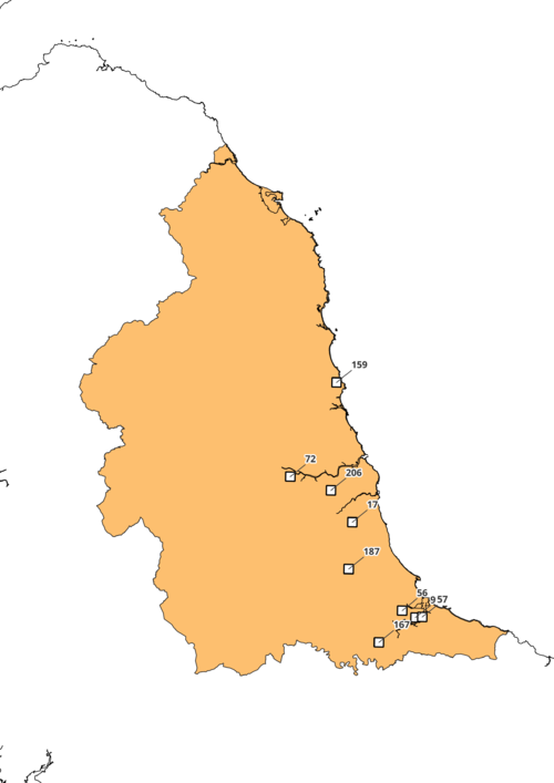
===North East=== | |||
{{#clear_external_data:}} | |||
{{#get_db_data: db=engy |from=lfsites| where=classification='Non-Hazardous Landfill' and region='North East' |data=site=site,id=id,operator=operator}} | |||
[[File:Lf map neast nonhaz.png|500px|right]] | |||
{|Class="wikitable sortable" | |||
! ID !! Site Name !! Operator | |||
{{#for_external_table:<nowiki/> | |||
{{!}}- | |||
{{!}} {{{id}}}. | |||
{{!}} [[{{{site}}}]] | |||
{{!}} [[{{{operator}}}]] | |||
}} | |||
|} | |||
<br clear='all' /> | |||
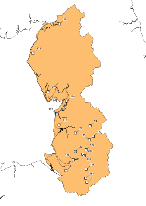
===North West=== | |||
{{#clear_external_data:}} | |||
{{#get_db_data: db=engy |from=lfsites| where=classification='Non-Hazardous Landfill' and region='North West' |data=site=site,id=id,operator=operator}} | |||
[[File:Lf map nwest nonhaz.png|500px|right]] | |||
{|Class="wikitable sortable" | |||
! ID !! Site Name !! Operator | |||
{{#for_external_table:<nowiki/> | |||
{{!}}- | |||
{{!}} {{{id}}}. | |||
{{!}} [[{{{site}}}]] | |||
{{!}} [[{{{operator}}}]] | |||
}} | |||
|} | |||
<br clear='all' /> | |||
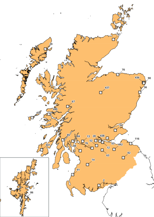
===Scotland=== | |||
{{#clear_external_data:}} | |||
{{#get_db_data: db=engy |from=lfsites| where=classification='Non-Hazardous Landfill' and country='Scotland' |data=site=site,id=id,operator=operator}} | |||
[[File:Lf map scotland nonhaz.png|500px|right]] | |||
{|Class="wikitable sortable" | |||
! ID !! Site Name !! Operator | |||
{{#for_external_table:<nowiki/> | |||
{{!}}- | |||
{{!}} {{{id}}}. | |||
{{!}} [[{{{site}}}]] | |||
{{!}} [[{{{operator}}}]] | |||
}} | |||
|} | |||
<br clear='all' /> | |||
===South East=== | |||
{{#clear_external_data:}} | |||
{{#get_db_data: db=engy |from=lfsites| where=classification='Non-Hazardous Landfill' and region='South East' |data=site=site,id=id,operator=operator}} | |||
[[File:Lf map seast nonhaz.png|500px|right]] | |||
{|Class="wikitable sortable" | |||
! ID !! Site Name !! Operator | |||
{{#for_external_table:<nowiki/> | |||
{{!}}- | |||
{{!}} {{{id}}}. | |||
{{!}} [[{{{site}}}]] | |||
{{!}} [[{{{operator}}}]] | |||
}} | |||
|} | |||
<br clear='all' /> | |||
===South West=== | |||
{{#clear_external_data:}} | |||
{{#get_db_data: db=engy |from=lfsites| where=classification='Non-Hazardous Landfill' and region='South West' |data=site=site,id=id,operator=operator}} | |||
[[File:Lf map swest nonhaz.png|500px|right]] | |||
{|Class="wikitable sortable" | |||
! ID !! Site Name !! Operator | |||
{{#for_external_table:<nowiki/> | |||
{{!}}- | |||
{{!}} {{{id}}}. | |||
{{!}} [[{{{site}}}]] | |||
{{!}} [[{{{operator}}}]] | |||
}} | |||
|} | |||
<br clear='all' /> | |||
===Wales=== | |||
{{#clear_external_data:}} | |||
{{#get_db_data: db=engy |from=lfsites| where=classification='Non-Hazardous Landfill' and country='Wales' |data=site=site,id=id,operator=operator}} | |||
[[File:Lf map wales nonhaz.png|500px|right]] | |||
{|Class="wikitable sortable" | |||
! ID !! Site Name !! Operator | |||
{{#for_external_table:<nowiki/> | |||
{{!}}- | |||
{{!}} {{{id}}}. | |||
{{!}} [[{{{site}}}]] | |||
{{!}} [[{{{operator}}}]] | |||
}} | |||
|} | |||
<br clear='all' /> | |||
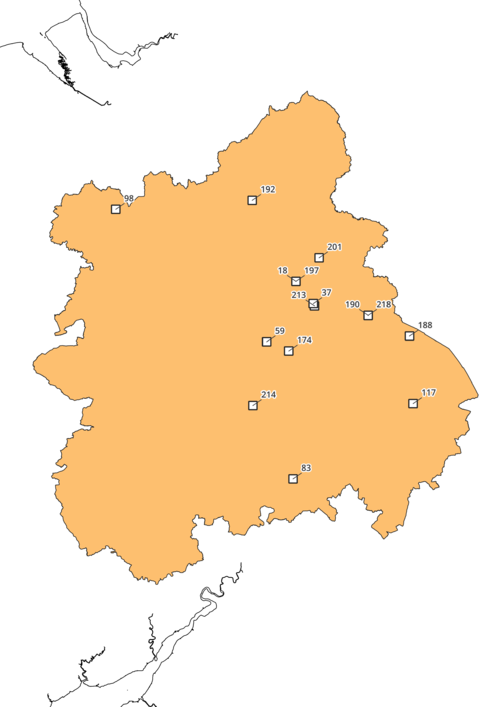
===West Midlands=== | |||
{{#clear_external_data:}} | |||
{{#get_db_data: db=engy |from=lfsites| where=classification='Non-Hazardous Landfill' and region='West Midlands' |data=site=site,id=id,operator=operator}} | |||
[[File:Lf map wmids nonhaz.png|500px|right]] | |||
{|Class="wikitable sortable" | |||
! ID !! Site Name !! Operator | |||
{{#for_external_table:<nowiki/> | |||
{{!}}- | |||
{{!}} {{{id}}}. | |||
{{!}} [[{{{site}}}]] | |||
{{!}} [[{{{operator}}}]] | |||
}} | |||
|} | |||
<br clear='all' /> | |||
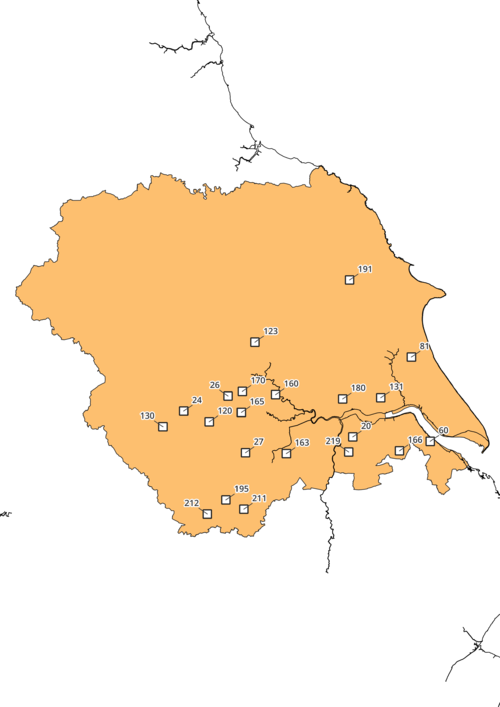
===Yorkshire & Humber=== | |||
{{#clear_external_data:}} | |||
{{#get_db_data: db=engy |from=lfsites| where=classification='Non-Hazardous Landfill' and region='Yorkshire & Humber' |data=site=site,id=id,operator=operator}} | |||
[[File:Lf map yorkhumb nonhaz.png|500px|right]] | |||
{|Class="wikitable sortable" | |||
! ID !! Site Name !! Operator | |||
{{#for_external_table:<nowiki/> | |||
{{!}}- | |||
{{!}} {{{id}}}. | |||
{{!}} [[{{{site}}}]] | |||
{{!}} [[{{{operator}}}]] | |||
}} | |||
|} | |||
<br clear='all' /> | |||
==References== | ==References== | ||
<references /> | <references /> | ||
Latest revision as of 09:51, 27 June 2022
Only a Non-Hazardous Landfill can accept Non-Hazardous Waste which includes Municipal Solid Waste (MSW) and any other Non-Hazardous Waste of a similar nature that meets the relevant Waste Acceptance Criteria (WAC).
Arrangements
Only a Non-Hazardous Landfill can accept Non-Hazardous Waste which includes Municipal Solid Waste (MSW) and any other Non-Hazardous Waste of a similar nature that meets the relevant Waste Acceptance Criteria. They can also accept Inert Waste and Stabilised Non-Reactive Hazardous Waste (SNRHW), for example those vitrified or solidified[1]. The WikiWaste page Landfill frames these types of sites and puts them into a wider context.
Non-Hazardous Landfill Capacity (Void)
England
The capacity of Non-Hazardous Landfill is reported[2] by the EA for England and is summarised in the graph and table below, but it excludes that capacity of Non-Hazardous Landfill with a Stabilised Non-Reactive Hazardous Waste cell (which comprised 89.4 million cubic metres in 2015 dropping to 69.4 million cubic metres in 2019 and 67 million cubic metres in 2020 - which is summarised on the Hazardous Landfill page). Note that Non-Hazardous Landfill also provides Landfill capacity for Inert Waste in the sense that these waste are used for daily cover and site engineering purposes.
The number of sites in 2020 in England was 113, a drop from 118 in 2019, whilst capacity increased between the two years.
| <graph>{
"width":400, "height":200, "data":[{ "name":"table", "values":[ {"x":2015,"y":230.3},{"x":2016,"y":211.9},{"x":2017,"y":194.4}, {"x":2018,"y":185.2},{"x":2019,"y":160.2},{"x":2020,"y":164.8} ] }], "scales": [ {
"name": "x",
"type": "linear",
"range": "width",
"zero": false,
"domain": {"data": "table", "field": "x"}
},
{
"name": "y",
"type": "linear",
"range": "height",
"nice": true,
"domain": {"data": "table", "field": "y"}
}
], "axes": [ {"type": "x", "scale": "x", "format":"d","title":"Year"},
{"type": "y", "scale": "y", "grid":true, "title":"Million Cubic Metres"}
], "marks": [ {
"type": "line",
"from": {"data": "table"},
"properties": {
"enter": {
"x": {"scale": "x", "field": "x"},
"y": {"scale": "y", "field": "y"},
"stroke": {"value": "steelblue"},
"strokeWidth":{"value":2}
}
}
},
{ "type": "symbol",
"from": {"data": "table"},
"properties": {
"enter": {
"x": {"scale":"x","field": "x"},
"y": {"scale":"y","field": "y"},
"fill": {"value": "steelblue"},
"size":{"value":15}
}
}
} ] }</graph> |
| Year | 2015 | 2016 | 2017 | 2018 | 2019 | 2020 |
| Million Cubic Metres | 230.3 | 211.9 | 194.4 | 185.2 | 160.2 | 164.8 |
England by Region
All data 2020[3]. Please note that the "Number of Sites" in the table below relates to those sites that have returned a reported void. This figure does not necessarily correspond to the total number of sites in a region.
| Region | Number of Sites | Total Void (m3) | Average Void per site (m3) |
|---|
Scotland
All Data for 2019, owning to a cyber attack at SEPA there is currently no 2020 data.
| Region | Number of Sites | Total Void (t) | Average Void per site (t) |
|---|
Wales
Void data for 2018 for wales, Site Count Data is 2020.
| Region | Number of Sites | Total Void (m3) | Average Void per site (m3) |
|---|
Operational Landfill
East Midlands

East of England
London
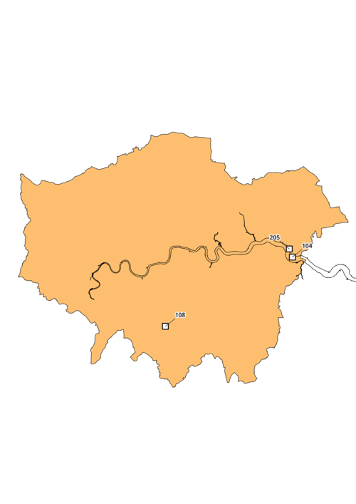
| ID | Site Name | Operator
|
|---|---|---|
| 104. | Rainham Landfill | Veolia ES Landfill Ltd |
| 108. | Beddington Farmlands Landfill Site | Valencia Waste |
| 205. | Silt Lagoons, Rainham and Wennington Marshes | Land & Water Remediation Ltd |
North East
North West
Scotland
South East

South West

Wales

West Midlands
Yorkshire & Humber
